Lori Berd
Medieval fortress-town between two river gorges
- Area Lori
- Type Fortress
- Time needed 45m
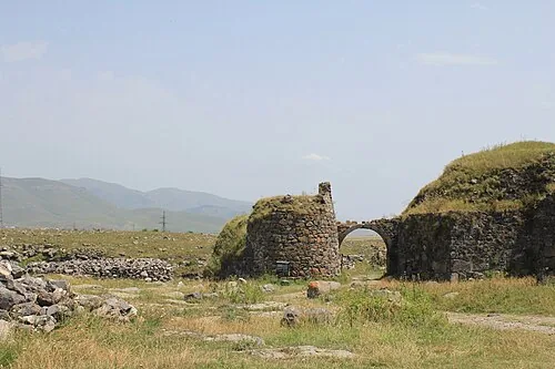
The remains of a medieval fortress-town on a triangular plateau between two river gorges near Stepanavan. The defences used the cliffs on two sides, and the site is read more through its position than through standing buildings.
Open in the planner →Getting there
About 129 km from Yerevan, roughly 2h 21m by car, on a side road from Stepanavan across open upland. A track leads to the plateau and you walk the site from there.
What you see
A long defensive wall and gate across the neck of the plateau, with foundations, cisterns and the remains of a bath house inside. The gorges drop away sharply on both flanks, and an old stone bridge survives in the valley below. Grass has grown over much of the interior, so the plan takes some working out.
What to pair it with
Combines with Stepanavan and the Dendropark arboretum, and with the Debed valley monasteries if you are heading on north.
When to go
Late spring to autumn. The plateau is high, windy and fully exposed, and winter visits are cold with poor footing.
What is hard about it
Most of the town is at foundation level, so there is little to look at beyond the wall and the gorge edges. There is no interpretation on site and the cliff edges are unprotected, which matters with children.
Common questions
How much is still standing?
The main wall and gate, the bath house remains and various foundations. The rest is outline and rubble under grass.
Is there an entrance or a visitor centre?
No formal facilities have been reported. [VERIFY — confirm current details]
Is it safe to walk around?
Yes with care. The edges of the plateau are sheer and unfenced, and the ground is uneven.
Nearby
- Haghpat MonasteryUNESCO-listed 10th-century monastery above the Debed
- Sanahin MonasteryUNESCO-listed monastery and medieval academy
- Sanahin Bridge12th-century stone bridge over the Debed river
- Odzun Church6th-century basilica on a plateau above the canyon
- Akhtala MonasteryFortified monastery with remarkable frescoes
- Kobayr MonasteryCliffside monastery with Georgian-style frescoes
More of the same kind
- Erebuni FortressUrartian citadel from 782 BC, the birthplace of Yerevan
- Amberd FortressCliff-top fortress on the slopes of Mount Aragats
- SmbataberdRidge-top fortress high above the Yeghegis valley
- Black FortressRound 19th-century Russian fort above Gyumri